This was not the first time that I had walked along this path. Back in the early 1990's my wife gave me a book called the Long Distance Trails Almanac. From this we decided to walk the Coed Morgannwg Way. At that time it went from Craig y Llyn to Margam Country park (the extension to Aberdare & Methyr Tydfil seems to have been added later). My parents dropped us off by Craig y Llyn and we spent two days completing the walk. Recalling the trip I mainly remember trees, lots and lots of trees (the clue is in the name Coed Morgannwg means Glamorgan woods). Also forest tracks, and eating lava bread for breakfast at a B&B. I do not recall any navigational problems (and this was before GPS devices were around for walkers); if anything the trail seemed a little boring, but in a nice way.
This time was different.
For a start there were fewer trees. Many of them have been felled; maybe they will be replanted but in many places they have been replaced by wind turbines and their infrastructure of extensive gravel roadways.
Secondly it was hard to find the trail in many places. Signs and waymarks have faded away or otherwise disappeared and parts of the trail have been overgrown by brambles, or otherwise blocked. Many new trails, especially bike trails, have been created, so there are posts with numerous signs, but none of them refer to the Coed Morgannwg Way.
But there were new cafes on route that I do not remember before, with coffee and cake, so not all the change is bad.
I had planned the trip based on it being 58 kms (36 miles), just about manageable in two days. In fact I walked 74.6 kms (46.6 miles) with an accumulated climb of 2158 m, mainly on the second day. Deducting the navigation errors and obstructions that caused me to retrace my steps, the route was 65.7 km (41 miles long). with 1886 m of ascent. Two days was a stretch and walking the route in three days, or a least in summer when there are more hours of daylight, would have been a better option. A gpx file of the route I walked can be downloaded from www.wikiloc.com; however the correct route with the various footpath diversions and corrections to my route can be found by this link. One or both of these files is recommended as it is more detailed and accurate than the one I used from gps routes and you can actually walk it on the ground. The route I walked is also available on Viewranger.com under short code johnpon0013.
Tuesday 15 November 2016
Monday 14 November 2016
Craig y Llyn to Margam Country Park
Day two of my walk started early, waking at 5:00 a.m. after my early night. I packed up and was on the trail by 6:00 a.m. by the light of my head torch. My campsite was located high up (for South Wales) near the 600 m contour and the mountain was in a thick mist that lasted much of the day. I look forward to such early starts as there is often a chance to see deer or other animals, but today all was quiet. The path was reasonably straightforward. There were many gravel roads for the wind turbines, on which an early morning tractor passed, with myriad lights ablaze, bringing a trailer full of gravel I guessed for more road building. Long lines of orange cones marked the edges of the gravel roads for any partially sighted drivers. Wind turbines may provide environmentally responsible power, but the landscape is left rather less green by their construction. A short section of a smaller but serviceable path, with some flags of rock, made a pleasant change for a while. Wind turbines appeared and disappeared in the mist and cloud. Trees, dripping water onto my head, alternated with moorland of long, unkempt grass that drenched my trousers. Promised views were obscured by mist.
Soon, at a bleak junction in the clouds, I joined the St Illtyd's way, another long distance path, which follows the Coed Morgannwg Way as far as my destination at Margam Park. I celebrated with a breakfast of cheese and flapjacks. Then I missed a turning and had to retrace my steps again.
But the turning proved hard to find. Close examination indicated the distant remains of a path at about the right place, long since grown over with brambles, long grass and small fir trees . Battling through I discovered a stile with a rare Coed Morgannwg waymark. Further on it became impassable due to fallen trees and I crossed over a stream into woods where it was easy to push through, breaking off thin, brittle, dead branches that tried to stop me, eventually reaching a forest track. An easier way would be down a bike route called White's level (with the symbol of a coal wagon) which crosses the overgrown section of the Coed Morgannwg Way, but there is a risk of being injured by a fast moving mountain bike (signs warn you of this). The name White's level presumably refers to the coal mining industry, long gone, but apparent from an adit (a tunnel entrance) closed off with a Coal Authority sign.
Farther on the route turns up a small path climbing out of the Cwm Cragen valley. Not everyone wants you to take it; the post marking the turning has been chopped down (I was wrong, on a subsequent visit I discovered it had been removed as the path had been diverted, see update below). This path ends at a forest track, then the route zig zags up a hillside of tree stumps. With the mist clearing the village of Cymmer was visible down the valley as I again entered trees following a track along the side of the ridge. Reaching a viewpoint I accidentally took a bike trail down to a lower parallel track, misreading a waymark, The ruins of a 17th century farm follows, where more recently they bred pit ponies who spent their lives in the dark, hauling coal through the mines. At Bryn Bettws Lodge I checked out the cafe, unfortunately closed. If you are walking the trail, it does offer camping and log cabins, although aimed at mountain bikers rather than walkers.
I then crossed over the River Avan the long way. I should have crossed a footbridge close to the Afan Forest visitor centre, but instead I followed the footprint signs that normally waymark the Coed Morgannwg Way to a pedestrian bridge further west, built where a railway once ran, and then had a lengthy walk back to the visitors' centre. My problem was that footprint symbols, the same as those used to mark the Coed Morgannwg Way, are used to mark local, and quite different, walks in the Afan Forest Park. The visitor centre had a cafe (for a welcome coffee and carrot cake), a camp site for tents (hidden behind the centre) and a mining museum which I would have liked to visit. On this trip I lacked the time as I estimated I would reach Margam Park at around 6:00 pm; sunset was at 4:30 pm. The footprint waymarks around the visitor centre left me confused, so I headed uphill on a track alongside the steam as indicated on the map, steadily climbing up to the summit, where a path coming from the right had a St Illtyd waymark, suggesting I had come up the wrong path.
The route now takes a 2 km half circle around the end of the ridge. I was making good progress, almost around the loop when I was faced with a barbed wire fence and a danger sign due to quarrying. Ignoring the sign was tempting but years in industry having a safety message drummed into me, and me drumming it into others, made me retrace my steps. There were two possible alternative routes. With the benefit of hindsight, the Cicerone guide describes one but I took another that I was more certain would avoid the quarry, taking a wide half circle to rejoin the Coed Morgannwg Way as it drops down to Bryn.

The Royal Oak at Bryn looked tempting but I still had a long way to go, and the weather was deteriorating. As the mist turned to rain I headed up over the next ridge, now estimating a 6:30 pm arrival at Margam. Thankfully the route now followed reasonably clear paths, but the poor light filtering through the clouds was rapidly turning to darkness. I reached a point where the St Illtyd's sign pointed one way but the GPS said another. I went with the GPS as the waymarking was too unreliable and too easy to miss in the dark. Checking later I found I had also missed a hill fort in the dark. Even large junctions in the track could be passed without me spotting them, causing me to retrace my steps at one point where the GPS indicated I had missed a turning. Then I came to a point at which the GPS suggested I had missed another turning, so I retraced my steps but could see no path. By now I was relying on my headtorch, which at best illuminates a small area, but the drizzly rain was reflecting much of the light back into my eyes, illuminating even less (like full headlights on a foggy night). In consequence I banged my head into a low, but solid, branch. I returned to the path I was following and the turning came somewhat later than the GPS track indicated.
Thankfully this was my last navigational difficulty; I just had to continue carefully along the path, as with the limited light from my head torch and the wet rocks on the uneven ground, there was a high risk of tripping. The other risk was that the gates to Margam Country Park would be locked. Fortunately this was not the case and I could enter and leave the park through pedestrian gates (setting off a security light as I left but fortunately no alarms).
Now rather wet, I waited for my very kind wife to pick me up at the entrance to the park while eating some peanuts and raisins I had left and putting on extra clothes as I cooled down. My salvation arrived ahead of time and I was glad to jump in the car, to be welcomed not only by my wife but also by enthusiastic kisses from Lola (the dog).
Update: I returned to the area around the Afan Argoed Visitor centre to try and find where I should have gone. In the following I have assumed that the Coed Morgannwg Way is the same as St Illtyd's Walk in this area, They are indicated as following the same route on the map, but then again the waymarks for St Illtyd's Walk are not where my Ordnance Survey map says they should be. On the north side of the River Avan, based on fairly frequent waymarks, it seems that St Illtyds Walk has been diverted onto a low route along a north side of the river, following an old train line. The diversion starts where I saw the post chopped down at a turn off for the previous route. It is a pleasant track but without the views of the ridge path described above.
On the south side of the river, the first waymark for St Illtyd's walk is craftily hidden behind the visitor centre. It takes you around to the east of the route on the map, onto high ground with pleasant views, but rather muddy in December. It then crosses the route on the map and heads south avoiding the warning signs for the quarry, which you eventually pass on your left. There are other routes you can follow, but this one largely avoids being hit by fast moving bikes. See the Overview post for a gpx file of the revised route.
 |
| Roads servicing the windfarm |
 |
| Wind turbine appearing through the cloud |
But the turning proved hard to find. Close examination indicated the distant remains of a path at about the right place, long since grown over with brambles, long grass and small fir trees . Battling through I discovered a stile with a rare Coed Morgannwg waymark. Further on it became impassable due to fallen trees and I crossed over a stream into woods where it was easy to push through, breaking off thin, brittle, dead branches that tried to stop me, eventually reaching a forest track. An easier way would be down a bike route called White's level (with the symbol of a coal wagon) which crosses the overgrown section of the Coed Morgannwg Way, but there is a risk of being injured by a fast moving mountain bike (signs warn you of this). The name White's level presumably refers to the coal mining industry, long gone, but apparent from an adit (a tunnel entrance) closed off with a Coal Authority sign.
 |
| Overgrown path |
 |
| Looking down the valley towards Cymmer |
 |
| Felled areas |
 |
| View of the Avan valley from the wrong footbridge |

The Royal Oak at Bryn looked tempting but I still had a long way to go, and the weather was deteriorating. As the mist turned to rain I headed up over the next ridge, now estimating a 6:30 pm arrival at Margam. Thankfully the route now followed reasonably clear paths, but the poor light filtering through the clouds was rapidly turning to darkness. I reached a point where the St Illtyd's sign pointed one way but the GPS said another. I went with the GPS as the waymarking was too unreliable and too easy to miss in the dark. Checking later I found I had also missed a hill fort in the dark. Even large junctions in the track could be passed without me spotting them, causing me to retrace my steps at one point where the GPS indicated I had missed a turning. Then I came to a point at which the GPS suggested I had missed another turning, so I retraced my steps but could see no path. By now I was relying on my headtorch, which at best illuminates a small area, but the drizzly rain was reflecting much of the light back into my eyes, illuminating even less (like full headlights on a foggy night). In consequence I banged my head into a low, but solid, branch. I returned to the path I was following and the turning came somewhat later than the GPS track indicated.
Thankfully this was my last navigational difficulty; I just had to continue carefully along the path, as with the limited light from my head torch and the wet rocks on the uneven ground, there was a high risk of tripping. The other risk was that the gates to Margam Country Park would be locked. Fortunately this was not the case and I could enter and leave the park through pedestrian gates (setting off a security light as I left but fortunately no alarms).
Now rather wet, I waited for my very kind wife to pick me up at the entrance to the park while eating some peanuts and raisins I had left and putting on extra clothes as I cooled down. My salvation arrived ahead of time and I was glad to jump in the car, to be welcomed not only by my wife but also by enthusiastic kisses from Lola (the dog).
Update: I returned to the area around the Afan Argoed Visitor centre to try and find where I should have gone. In the following I have assumed that the Coed Morgannwg Way is the same as St Illtyd's Walk in this area, They are indicated as following the same route on the map, but then again the waymarks for St Illtyd's Walk are not where my Ordnance Survey map says they should be. On the north side of the River Avan, based on fairly frequent waymarks, it seems that St Illtyds Walk has been diverted onto a low route along a north side of the river, following an old train line. The diversion starts where I saw the post chopped down at a turn off for the previous route. It is a pleasant track but without the views of the ridge path described above.
 |
| Diverted route on north side of River Avan, an old railway |
On the south side of the river, the first waymark for St Illtyd's walk is craftily hidden behind the visitor centre. It takes you around to the east of the route on the map, onto high ground with pleasant views, but rather muddy in December. It then crosses the route on the map and heads south avoiding the warning signs for the quarry, which you eventually pass on your left. There are other routes you can follow, but this one largely avoids being hit by fast moving bikes. See the Overview post for a gpx file of the revised route.
Sunday 13 November 2016
Methyr Tydfil to Craig y Lyn
Based on the Ordnance Survey map and the gpx file I had downloaded onto my GPS the Coed Morgannwg Way should start at a Bike Park near Methyr Tydfil. I say "should" as there were no signs or waymarks to indicate the start of a long distance footpath, none of the white footprints on a brown background that are said to define the trail. Nevertheless, on a Sunday morning the Bike Park was full of people on muddy mountain bikes, milling around, and there was a cafe where I bought some bottled water to replace the bottle I accidentally left in the car. (I could have taken the train to Methyr and walked to the start of the trail from there, but my kind, long suffering wife dropped me off (minus a water bottle).
I soon left the lycra - clad bikers to their extreme paths and followed the direction indicated by my map and GPS (the two closely followed each other). After a short section of farm track they lead me over a stile and then my troubles began. I think it unlikely that the person who defined this section of the Coed Morgannwg Way on the map ever actually set foot on the ground. If they had done so, they would have realised that while it may be "open access" land, across which you can legally roam freely, in the event, dense woodland, brambles and fences actually means you cannot. I zig zagged across the ground attempting to find passable routes in the general direction indicated by the map. This resulted in me retracing my steps several times as I found paths, little and larger that I could follow, and stiles across fences.. Even public footpaths on the map seemed to have limited reality on the ground, all without signs, many long overgrown, blocked by fallen trees and apparently little used. Some of those paths that I followed seemed to me more used by animals or motor bikes than walkers. Eventually (to the sound of nearby clay pigeon shooting) I reached a track weaving back and forth under an electricity line that was easy to follow. According to the map the Coed Morgannwg Way exactly follows an electricity line; maybe whoever defined it mistook the electricity line symbol (a dashed line) for a path (also a dashed line). It may be that the map was very vague in its marking and that I missed the correct route, so maybe I will return, try again, be successful and update this blog.
The next bit of the route through the Gethin woods was a little easier, muddy in places, with deep ruts left by vehicles, but not too surprising for a November day. It was not raining, which was a blessing and the last yellow leaves of Autumn were falling from the trees. But I should have kept a closer eye on the GPS as, distracted by a bunch of motor bikers on scrambling bikes, I missed a turn and was forced to retrace my steps. Following the GPS route too slavishly was also an issue, leading me down motor cycle tracks that may or may not have been the correct route, but which finally lead me to the edge of the modern housing at Cwmbach and my very first Coed Morgannwg waymarks ( mysteriously mutated to a black footprint on a white background). I topped up with water and a plougman's roll at the local Petrol station and headed on into Aberdare briefly following the Aberdare canal, a historical remnant from the days of coal mining and iron works. Leaving the Victorian terraced houses and more modern ones behind I followed the route along an old abandoned railway line, past dog walkers and children in prams to the Dare Valley Country park. The O.S. map here shows the Coed Morgannwg Way diagonally crossing a field which showed no evidence of any path. However, I was beginning to realise that the route on the O.S. map marked by green diamonds was joining up some sparsely spaced (and poorly positioned) points, and was not necessarily following the intended footpaths and tracks which were somewhere nearby. So much for the accuracy of the Ordnance Survey! On the plus side the Country Park had a cafe with coffee and chocolate cake. There is also a hotel and campsite, however, I was planning to camp further on.
Leaving the visitor centre I headed up the hillside to Craig Pen-rhiw-llech, a dramatic feature that appears to be a corrie carved by some ancient glacier at the end of the last ice age. There were some great views back across Abderdare and Cwmbach to where I had crossed the ridge from Methyr. At the top I found my first stone marker for the Coed Morgannwg Way; a square block of rock with a black footprint on it. Discouragingly, there was also a notice saying that a variety of footpaths were closed.
I dislike these notices and in particular this one as it had no map and it would have taken a lengthy period to work out from grid references, on a map flapping in the wind, where it referred to. Even when such signs have maps they are generally black and white, and very difficult to work out what they refer to. In addition it is not helpful on an "A to B" walk to find when you have just climbed a big mountain that the path ahead is closed. I did what any sensible hiker does and ignored this bit of legal obfuscation.
I now crossed a section of rough moorland, past a reservoir and then passed my first wind turbines, giant beasts that dominate the landscape. The next major milestone was reaching the main A4061 road. The path should have restarted just across the road, and maybe it once did, but now it was rough ground and the ghost of a track had holes full of water and sphagnum moss that your legs would suddenly disappear into. I had once damaged my knee in such a landscape and, not wishing a second arthroscopy, I decide to find another route. Two possibilities: either head north up the road to where a bridle path was marked (a route recommended in one book) or following the cycle path beside the route heading south. I chose the latter as it avoided walking on the road in the gathering gloom. It shortly headed west in the right direction, but first it passed the security office for a project that seemed to involve installing more wind turbines. I tried to sneak past as I was not sure they would be happy with me camping out, possibly in their windfarm, and as nightfall was rapidly approaching there was little else I could do, heading into an area populated only by trees and wind turbines. However the lights went on, the barrier went up and the guard looked out of the window. Fortunately he just waved, I waved back and hurried on my way.
A few kilometres later and I was back on the Coed Morgannwg Way somewhere above the lake of Llyn Fach. I knew this because of my GPS, but it was now, at 5:30 p.m., too dark to see anything but the orange lights of Hirwaun down in the valley. Reaching for my head torch I pushed into the fir trees and found a patch on the pine needles large enough for my small tent. By 8:30 pm I was asleep.
Update: I returned on a wet and muddy day in December to try and find out if and where my navigating was in error. First error - I had started at the wrong place, I found a Coed Morgannwg Waymark at the bridge over the A470 a little way North East of the Bike park, although the indicated bridle way just led up the the Bike path so not much of an error. More seriously I struggled to find a better way between the Bike Park and the electricity pylons. I tried following good tracks (which I took to be the public bridleways marked on the map) to the North East of the route indicated on the Ordnance Survey map, and succeeded in finding two good alternatives, but I had to ignore signs saying "Keep Out" warning of old coal mine workings. There was clearly no risk if you kept to the tracks and the many signs seemed an over reaction, but you cannot ignore such warnings. This is a pity as this route went past a short path leading to a 16th century blast furnace.

I did however find a better route as you approach Cwmbach and Aberdare, discovering two more waymarks, hiding in the bushes. This more correct route avoids the slippery motor bike paths through the trees I followed before. I have given a link to the corrected route in the gps file I refer to in the Overview post.
Finally, I checked the bridle path route at Craig y Lyn, which gives better views than the one I took previously via the windfarm security office (at least I think so it was lost in drizzle when I walked the section). It does however mean a 200 metre walk along a busy road or over very rough grass next to it. The bridle path starts close to a car park, where there was an assemblage of crosses and flowers commemorating dead Mums and Dads, Grandmas and Grandpas. A curious sight with a great view.
I soon left the lycra - clad bikers to their extreme paths and followed the direction indicated by my map and GPS (the two closely followed each other). After a short section of farm track they lead me over a stile and then my troubles began. I think it unlikely that the person who defined this section of the Coed Morgannwg Way on the map ever actually set foot on the ground. If they had done so, they would have realised that while it may be "open access" land, across which you can legally roam freely, in the event, dense woodland, brambles and fences actually means you cannot. I zig zagged across the ground attempting to find passable routes in the general direction indicated by the map. This resulted in me retracing my steps several times as I found paths, little and larger that I could follow, and stiles across fences.. Even public footpaths on the map seemed to have limited reality on the ground, all without signs, many long overgrown, blocked by fallen trees and apparently little used. Some of those paths that I followed seemed to me more used by animals or motor bikes than walkers. Eventually (to the sound of nearby clay pigeon shooting) I reached a track weaving back and forth under an electricity line that was easy to follow. According to the map the Coed Morgannwg Way exactly follows an electricity line; maybe whoever defined it mistook the electricity line symbol (a dashed line) for a path (also a dashed line). It may be that the map was very vague in its marking and that I missed the correct route, so maybe I will return, try again, be successful and update this blog.
 |
| Blocked path |
 |
| First sight of Coed Morgannwg waymark |
 |
| Aberdare Canal |
Leaving the visitor centre I headed up the hillside to Craig Pen-rhiw-llech, a dramatic feature that appears to be a corrie carved by some ancient glacier at the end of the last ice age. There were some great views back across Abderdare and Cwmbach to where I had crossed the ridge from Methyr. At the top I found my first stone marker for the Coed Morgannwg Way; a square block of rock with a black footprint on it. Discouragingly, there was also a notice saying that a variety of footpaths were closed.
I dislike these notices and in particular this one as it had no map and it would have taken a lengthy period to work out from grid references, on a map flapping in the wind, where it referred to. Even when such signs have maps they are generally black and white, and very difficult to work out what they refer to. In addition it is not helpful on an "A to B" walk to find when you have just climbed a big mountain that the path ahead is closed. I did what any sensible hiker does and ignored this bit of legal obfuscation.
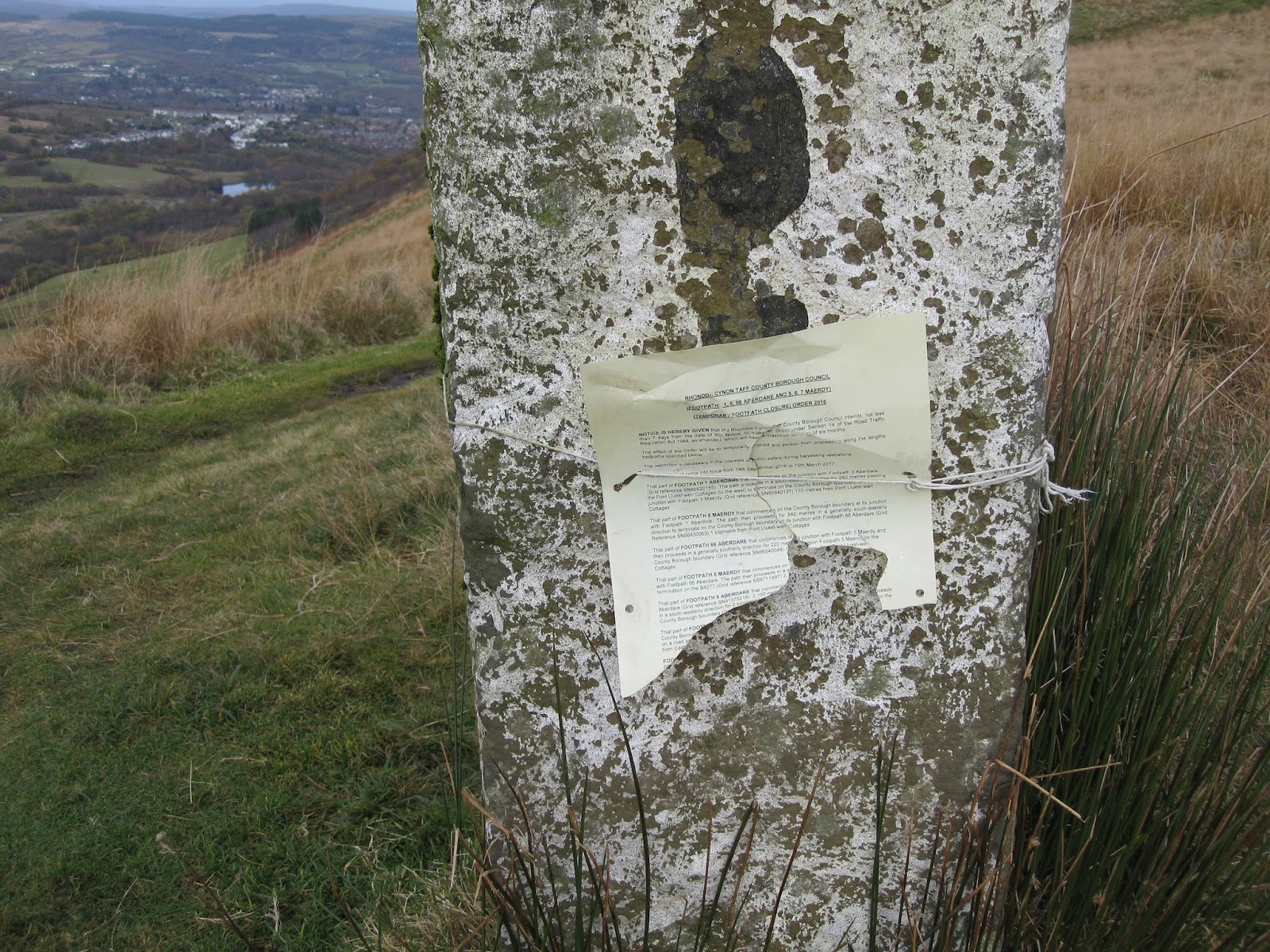 |
| Stone Coed Morgannwg Way marker with notice of footpath closures (somewhere) |
 |
| View across the escarpment as distant villages put their lights on |
 |
| Campsite |
Update: I returned on a wet and muddy day in December to try and find out if and where my navigating was in error. First error - I had started at the wrong place, I found a Coed Morgannwg Waymark at the bridge over the A470 a little way North East of the Bike park, although the indicated bridle way just led up the the Bike path so not much of an error. More seriously I struggled to find a better way between the Bike Park and the electricity pylons. I tried following good tracks (which I took to be the public bridleways marked on the map) to the North East of the route indicated on the Ordnance Survey map, and succeeded in finding two good alternatives, but I had to ignore signs saying "Keep Out" warning of old coal mine workings. There was clearly no risk if you kept to the tracks and the many signs seemed an over reaction, but you cannot ignore such warnings. This is a pity as this route went past a short path leading to a 16th century blast furnace.

 |
| 16th Century Blast furnace |
I did however find a better route as you approach Cwmbach and Aberdare, discovering two more waymarks, hiding in the bushes. This more correct route avoids the slippery motor bike paths through the trees I followed before. I have given a link to the corrected route in the gps file I refer to in the Overview post.
Finally, I checked the bridle path route at Craig y Lyn, which gives better views than the one I took previously via the windfarm security office (at least I think so it was lost in drizzle when I walked the section). It does however mean a 200 metre walk along a busy road or over very rough grass next to it. The bridle path starts close to a car park, where there was an assemblage of crosses and flowers commemorating dead Mums and Dads, Grandmas and Grandpas. A curious sight with a great view.
 |
| Typical muddy track, made more muddy by motor bikes |
 |
| Collection of crosses by car park near Craig y Lyn |
Subscribe to:
Posts (Atom)